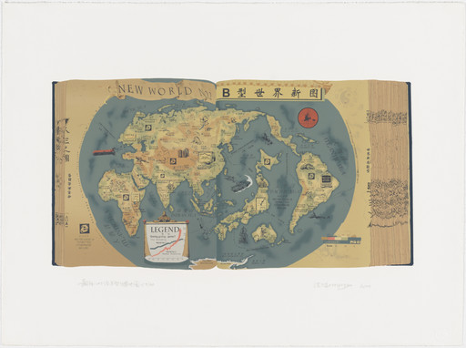
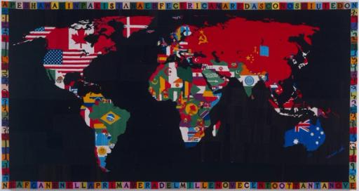
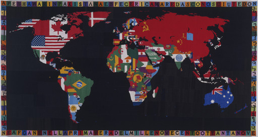
The World Map A and The World Map B resemble traditional Chinese thread-bound atlases that have been opened to a random page. Although ostensibly representing the world, these maps are filled with deliberate distortions, inaccuracies, and embellishments. The World Map A includes first-world nations and regions, including the United States, Canada, Europe, and Japan, while omitting the world’s more impoverished nations. In The World Map B, Hong Hao includes Latin America, Africa, Asia, and, again, an oversized Japan. Cryptic phrases, including “confidential” and “No release is termitted,” are often purposefully misspelled and allude to militaristic intentions. Hong inserts graphics and icons of industrialization and technology, such as satellites and the logo for the Internet Explorer web browser.
Rejecting geographic accuracy, Hong’s satirical maps serve as subjective representations of political, military, and economic power in the world. Hong explained, “I have long been interested in maps, especially historical maps, because they are capable of inspiring ideas on what we take as common knowledge. They are almost the most direct and the most economical way to know the world.”
Explore more
Maps, borders, and networks
People have been creating maps since ancient times. The earliest map, thought to be a schematic representation of the night sky, was found in the caves of Lascaux, France. It dates to 14,500 BCE.
Learn more →

From MoMA Design Store


Installation views
We have identified this work in the following photos from our exhibition history.
Licensing
Artwork or archival images
If you would like to reproduce an image of a work of art in MoMA's collection, or an image of a MoMA publication or archival material (including installation views, checklists, and press releases), please contact Art Resource (publication in North America) or Scala Archives (publication in all other geographic locations).
Audio and film clips
MoMA licenses archival audio and select out of copyright film clips from our film collection. At this time, MoMA produced video cannot be licensed by MoMA/Scala. All requests to license archival audio or out of copyright film clips should be addressed to Scala Archives at [email protected]. Motion picture film stills cannot be licensed by MoMA/Scala. For access to motion picture film stills for research purposes, please contact the Film Study Center at [email protected]. For more information about film loans and our Circulating Film and Video Library, please visit Circulating Film and Video Library.
Text from a publication or the archives
If you would like to reproduce text from a MoMA publication, please email [email protected]. If you would like to publish text from MoMA's archival materials, please fill out this permission form and send to [email protected].
Feedback
This record is a work in progress. If you have additional information or spotted an error, please fill out this feedback form.